

Dr. Edward Thiel
Geo-physicists from the University of Wisconsin
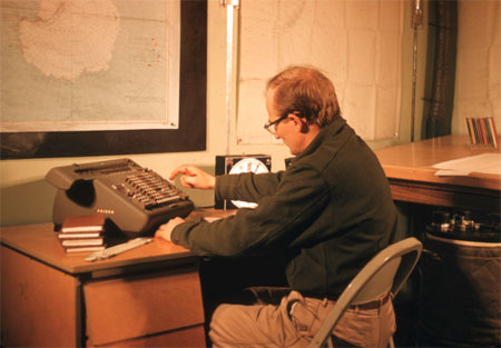
Geologist Edward Thiel reducing data using the Friden calculator inside the science building at Ellsworth Station. The instrument in the lower right is a Frost gravimeter used to measure the sea tide of the floating Filchner Ice Shelf. Ellsworth was one of seven U.S. research stations constructed for the International Geophysical Year (IGY), 1957-1958. Thiel was killed during a later scientific expedition when the P2V airplane he was a passenger in crashed at Wilkes Station, Antarctica, in November 1961.
Photograph by: Dr. John C. Behrendt
Date Taken: Austral winter 1957
Photo courtesy of National Science Foundation, USAP Photo Library
Places Named in Thiel's Honour
Description: Isolated, mainly snow-capped mountains, 45 mi long, located roughly between the Horlick Mountains and the Pensacola Mountains and extending from Moulton Escarpment on the west to Nolan Pillar on the east. Major components include Ford Massif (2,810 m), Bermel Escarpment and a group of eastern peaks near Nolan Pillar. Observed and first positioned by the USARP Horlick Mountains Traverse Party, 1958-59. Surveyed by the USGS Thiel Mountains parties of 1960-61 and 1961-62. Named by US-ACAN after Edward C. Thiel, traverse seismologist at Ellsworth Station and the Pensacola Mountains in 1957. In December 1959, he made airlifted geophysical observations along the 88th meridian West, including work near these mountains. Thiel perished with four others in the crash of a P2V Neptune aircraft soon after take-off from Wilkes Station, Nov. 9, 1961.
| Antarctica ID: | 15183 |
| Feature Name: | Thiel Mountains |
| Class: | Summit |
| Latitude: | 851500S |
| Longitude: | 0910000W |
| Elevation ft/m: | 9219 / 2810 |
Description: A submarine trough trending NE-SW with depths reaching to 1,500 m below sea level. The trough extends SW from c. 7630S, 3500W, in the Weddell Sea; underlies Filchner Ice Shelf and the S part of Ronne Ice Shelf, S of Henry Ice Rise; and continues W to c. 8300S, 8500W, near Martin Hills. The portion NE of Henry Ice Rise was discovered in 1957-58 by a U.S. traverse party from Ellsworth Station and named "Crary Trough" after Albert P. Crary, Chief Scientist, USARP. The SW portion was traced by U.S. seismic traverse parties, 1958-64, and the whole delineated in greater detail by the SPRI-NSF-TUD airborne radio echo sounding program, 1967-79. The name "Crary Trough" was set aside by US-ACAN at the suggestion of Dr. Crary, who recommended that the entire trough be named after Edward C. Thiel (1928-61), chief seismologist at Ellsworth Station, 1956-58, and leader of the traverse party that discovered this feature.
| Antarctica ID: | 15184 |
| Feature Name: | Thiel Trough |
| Class: | Valley |
| Latitude: | 813000S |
| Longitude: | 0570000W |