
Heard Island: V5 1997
Had a fairly rough night Monday night. Don't remember not sleeping, but remember waking up a lot. I went up to the bridge and sat in the chair on the very side of the bridge and watched us crashing into waves for an hour. They had the huge spot lights on and when we nosed dived into a big wave the sea would light up green. Someone said the biggest list we got up to was just under 50 degrees and Cameron the mate on watch said the swell was around 6 meters. Still less than voyage I came down on!!
We passed the McDonald Islands at lunch time. Ant Div has decided they are a special place not to be visited. This has the added advantage that non occupation doesn't harm our claim to sovereignty as we can say we care about them so much we are really looking after them by doing nothing. They are just some huge rocks in the middle of no where. But they looked great and I'd love to go there. Shrouded in mist and huge spires of rock with big waves pounding into the rocks.
A couple of hours later I was just putting in my contact lenses for Heard when I had a knock on the door. He had a problem with his GPS could I have a look at it. First they were going up to look at Heard. So I thought bugger your GPS I'm going to look at Heard too.
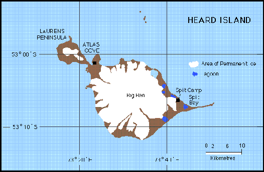
A map of Heard Island (stolen from some web site at Monash; originally
thanks to Ant Div I'm sure).
It had snuck up on us and was really close!! Luckily I'd grabbed the camera and jacket. The cloud level was at around 1200 feet but the seas were calm and we got great views of the huge cliff faces at the North West end coming around the point with Red Island at the end and then Heading into Atlas Cove. This is the bit that sticks off to the NW, but was still well and truly hidden in cloud. You could just see the tongue of the Jacka Glacier and then water falls from the melt, down the huge cliffs. The cliffs look like the are continually falling into the sea with big areas of fresh rock and piles of debris at the bottom.
Once into the entrance to Atlas Cove people were sent ashore by chopper. On one side we had Rodgers Head, with its 3 small volcanic cones. On the other side we had Navhoffensomething Bluff with the Jacka Glacier above it and Ice Fall Beach (with ice cliffs above it) and Black Cliffs along the coast heading out to sea. From the ship you could just see signs of the old ANARE station and a cross for the two blokes that died there. The best part is that there is green everywhere!!!
After 3 hours the chopper started bringing people back and weather has started to come in. I suppose it's getting dark also which makes it look gloomy.
Wednesday morning was great. Our ship time is way out from our local time. So at breakfast at 8am it was still very dark. The choppers were scheduled to start at 9.30, and after eating I went up to the bridge to see what was going down.
It was just getting light and it was looking like an unbelievable day. While there was 35 knots of wind, the whole of the Laurens Peninsula was visible. The captain decided to have a look in Corinthian Bay first and as we approached the very spectacular sweeping Baudissen Glacier the sun appeared from behind a squall and lit everything in a golden light. Many squalls were coming in from the NW obscuring land every so often.
It was decided that the ship couldn't be held steady enough for the choppers and we headed back out to try Atlas Cove again. As we went out we had a great view of the peaks of the Laurens Peninsula over Rodger's Head. Laurens Peninsula has 3 main peaks and looks like a miniature Heard Island to the NW joined by a narrow and low spit. Like Big Ben they are volcanic cones. Rodgers Head is the Headlands in between Atlas Cove and Corinthian bay and has 3 small cones on it which are fast being eroded by the sea. Rodgers Head is joined to the island by a mud flat that goes under water during rough seas. Its on this headlands that the first ANARE was set up 50 years ago.
Atlas Cove was even more spectacular than the previous day. The peaks, Mt Olsen, Mt Dixon, ANZAC Peak and Hayter Peak, are all snow and ice covered, with the Jacka Glacier flowing down from Mt Dixon and ice falls in other steep areas. Under the cliffs along the coast are huge piles of rock from land slides. At the very northern extremity is Red Island which appears off from some huge cliffs called The Sentinels. The Sentinels have huge vertical pillars of granite standing up and over them, like The Organ Pipes of Tassie. Big Ben, the main mountain on Heard Island (highest point being Mawson Peak) was cloud covered the whole time we were there. Some people got a glimpse of it from the south.
I got flown in at 12.30 for the 50th ANARE ceremony (which I missed by accident). We were landed at the old ANARE camp, the first ANARE which wintered in 1947, and remained active for a few years until it was abandoned for a continental station (Mawson). The original buildings are just ruins, with most just being frame work. The most unusual is a hexagonal building, of which one full frame remains and another is almost completely gone. There are also some French buildings from the early 70's which could offer some protection. The area is littered with machinery, bottles and other bits of junk. An old machine which could have been the original tractor is rusting at the edge of the camp, while on the other side on the mudflat is a trailernear an old wooden sign for the Bruce Highway.
After having a quick look at the camp I decided to walk over to the cross a 100 meter or so out to pay my respects at the memorial for the two men that died at Heard. 3 blokes had tried to take a short cut along the beach in front of a glacier and were caught by the fast changing weather. One was washed to sea, while the other two made it past, but got soaked. One tried to make it back by traversing the glacier but froze, and the other recovered enough to make it back in front of the glacier the next day. The memorial is in good repair, and has a breath taking view across Atlas Cove to the Lauren Peninsula peaks and The Sentinels. Many men died during the sealing day of the 1800's but few graves are known and marked.
To get to the memorial I had to cross green stuff!!!!!! After spending so much time being very careful to stand on small bits of dull lichen and moss, walking over GRASS and huge cushion plants seemed very wrong. I had to feel it, brush my face across the moss, and lay in the grass. I could finally walk across it. I'd forgotten how there are so many types of green things. They all look different. After 9 types of birds, 3 types of seals and a few obvious types of moss and lichen, the diversity and colour was mind blowing. The cushion plant forms tussocks a few feet high, and all the ground is very peaty and feels like walking on a mattress.
Next was the animals. Along the beach and amongst the tussock was heaps of Elephant seals. While they're not new for me, seeing them amongst green stuff was. There was also some juvenile Fur seals. Fur seals can sit up on their front flipper and the young are very agile and curious. They scamper around, often in groups, sneaking up on you, at a respectable distance, and run off when you look around. I got some great photos of them on the beach on my way back. They reminded me of Meer Cats the way they continually moved and sat up to see where I was.
There was two species of penguins, both new for me. The King penguins are very large and colourful. They have a wonderful trumpeting call like the Emperors, and have a very majestic air about them. By the colour I think most were adults and there were a often pairs identifying themselves to each other by letting out a long and increasing call as they raise their head from the chest and end up pointing to the sky. The Gentoo penguins were quite boring in comparison as they sat around and moulted.
I walked up the beach to where some blokes were installing a tide gauge. The beach was rounded boulders of volcanic rock and was littered with large amounts of matted kelp. There was some waves coming in and at the low lava cliffs a bit further on some spray was blowing in.
Where the blokes were working I found my main aim, the Heard Island choock. Also know as the Heard Island Sheathbill, it is a small white bird that looks like a small Bantam, doesn't like to fly, and wanders around pecking at the ground. It also has the reputation of eating anything, and running off with gloves. Its main means of defence from skua while flying is to turn into a rock and fall out of the sky. They are also very curious and come right up to you.
After a couple of hours I stupidly got too close to the camp and was grabbed and shoved on a chopper back to the ship. 90 people got ashore and I think everyone that wanted to got ashore at some stage. People with work on remote parts of the island got to see the huge colonies of penguins of 100,000's of birds and beaches so packed with seals they would have to hover to clear the ground before landing. The weather was exceptional for Heard and everyone was lucky.
Yesterday the weather wasn't near as good. By 2pm no land was visible and there was still parties ashore. Buck did some flying in very bad conditions and got everyone home and we headed off around 6pm. The seas are still very good at only a few meters and we're flying at 15 knots over the ground. We might even be home on time.
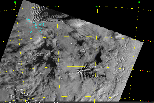
Thanks to the Mets at Casey, especially Christina, I have a few interesting satellite images of the weather patterns caused by Heard Island.
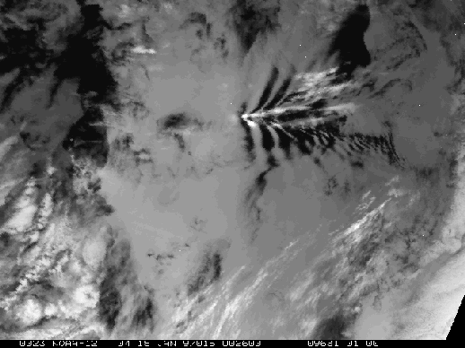
One of the images that led people to believe that Heard might be
erupting
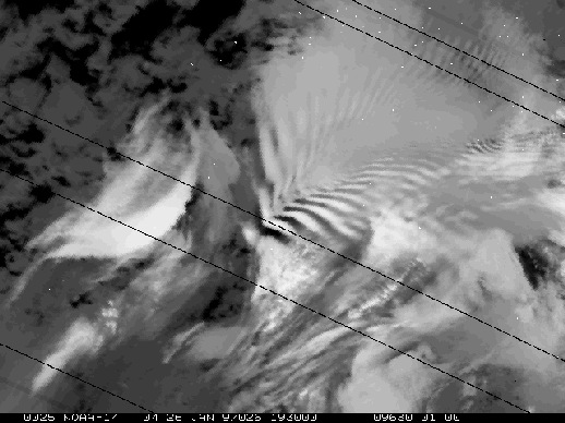
This has the most beautiful wave patterns in it.
This even includes Kerguelen Islands